Extreme weather, Convective storms
Compounding Synoptic and Mesoscale Drivers of the 17 September 2017 Severe Convective Outbreak in Romania: The Role of Insolation in Storm Severity”
Abstract
")
What I’m investigating
The central hypothesis is that afternoon insolation acted as the necessary trigger for an otherwise marginal thermodynamic configuration. The morning of 17 September was overcast across the Balkans. By midday, the sky cleared, and surface temperatures jumped from ~22 °C to over 30 °C in three hours - about 9 K above the September climatology. A few hours later, the storm was at its peak.
The questions I’m asking:
- Quantitatively, how much of the storm’s severity is attributable to that morning warming? Could the same synoptic setup have produced a non-event under persistent cloud cover?
- Why did standard composite indices (DCP) completely miss the threat? And does the High-Shear, Low-CAPE (HSLC) framework from Sherburn & Parker (2014) - developed for the U.S. southeast - apply to European derechos?
- Is this case unique, or does southeastern Europe see a recurring “warm-anomaly HSLC” sub-class of derechos that has slipped between the cracks of existing climatologies?
What I’ve done so far
This is a methodology demonstration, not yet a finalised study. Working from the published values in Sipos et al. (2021) and a reconstructed proximity sounding for Beograd Košutnjak (12 UTC, 17 September), I implemented the parcel thermodynamics in Python and produced four original analyses:
Finding 1: SBCAPE is a steep nonlinear function of surface temperature
Holding the synoptic environment above 925 hPa fixed and varying only the surface temperature, SBCAPE crosses from ≈ 0 J kg⁻¹ at T₂ₘ = 22 °C (an overcast-morning scenario) to ≈ 124 J kg⁻¹ at the observed afternoon value of 28 °C, and grows nonlinearly above that. This is the classic threshold-crossing shape of a convectively inhibited environment having its CIN consumed by parcel warming.
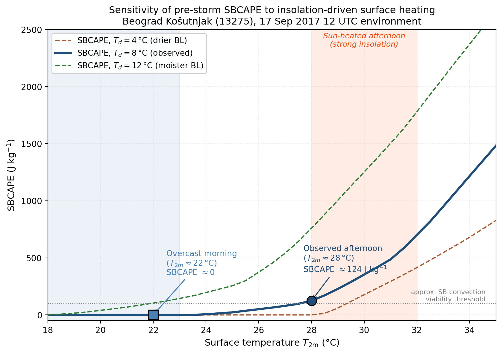
The implication: had the morning’s overcast persisted, the surface parcel would not have reached its level of free convection. The storm - at least as a surface-based system - needed those few hours of sun.
Finding 2: The event is an outlier in the European derecho parameter space
Compared against other documented European derechos (Berlin 2002, Slovakia 2008, Bulgaria 2011, the cold-season Central European event of March 2008, the Finland 2002 case) and against the Evans & Doswell (2001) U.S. warm-season median, the 17 September 2017 case sits at the extremes of four axes simultaneously - shear, lapse rate, surface-temperature anomaly, low-level dryness - while sitting at the minimum on MUCAPE.
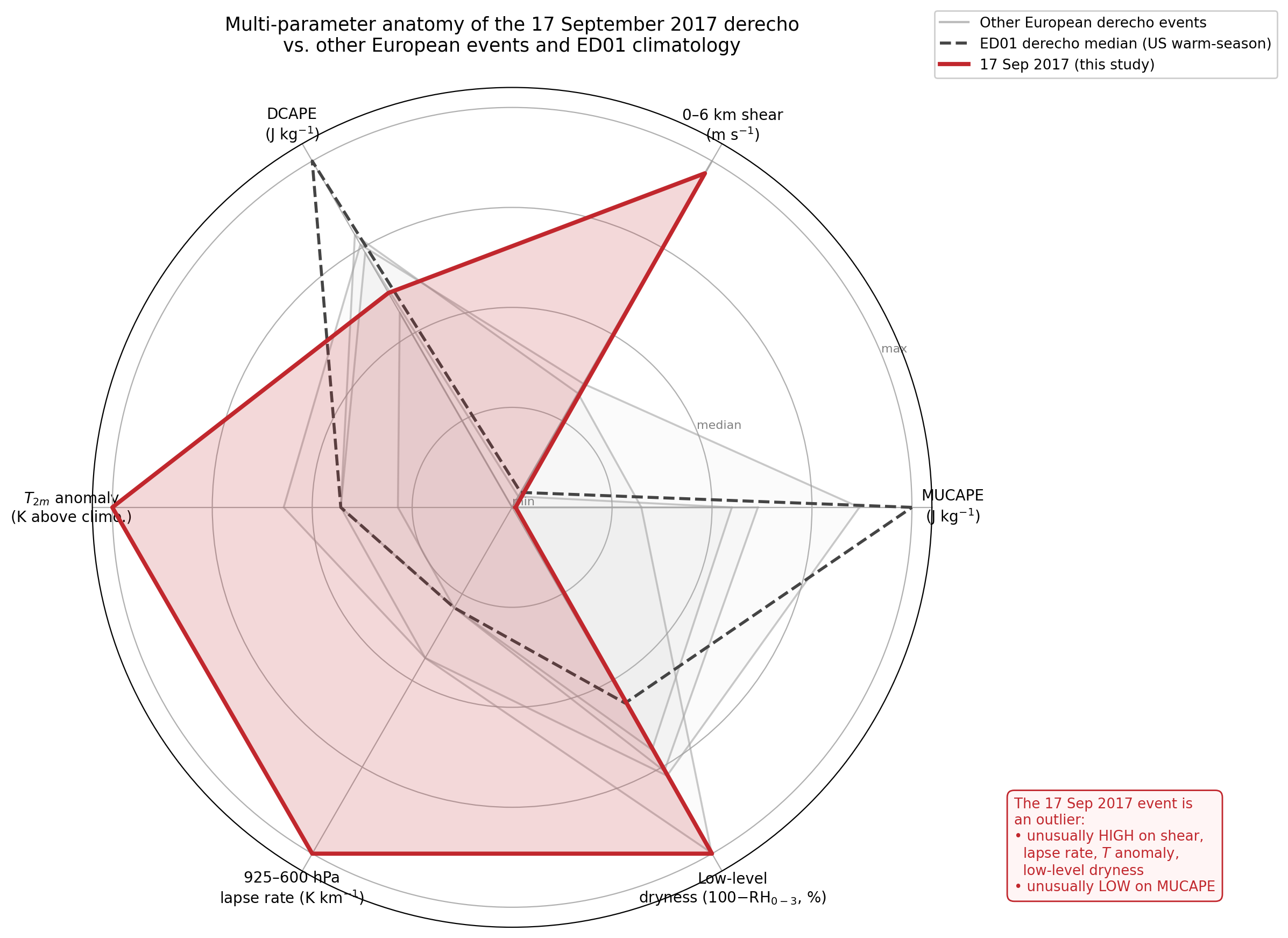
This is not the shape of a typical European derecho. It combines warm-season features (large positive temperature anomaly, surface-based convection) with cold-season features (low CAPE, very high shear).
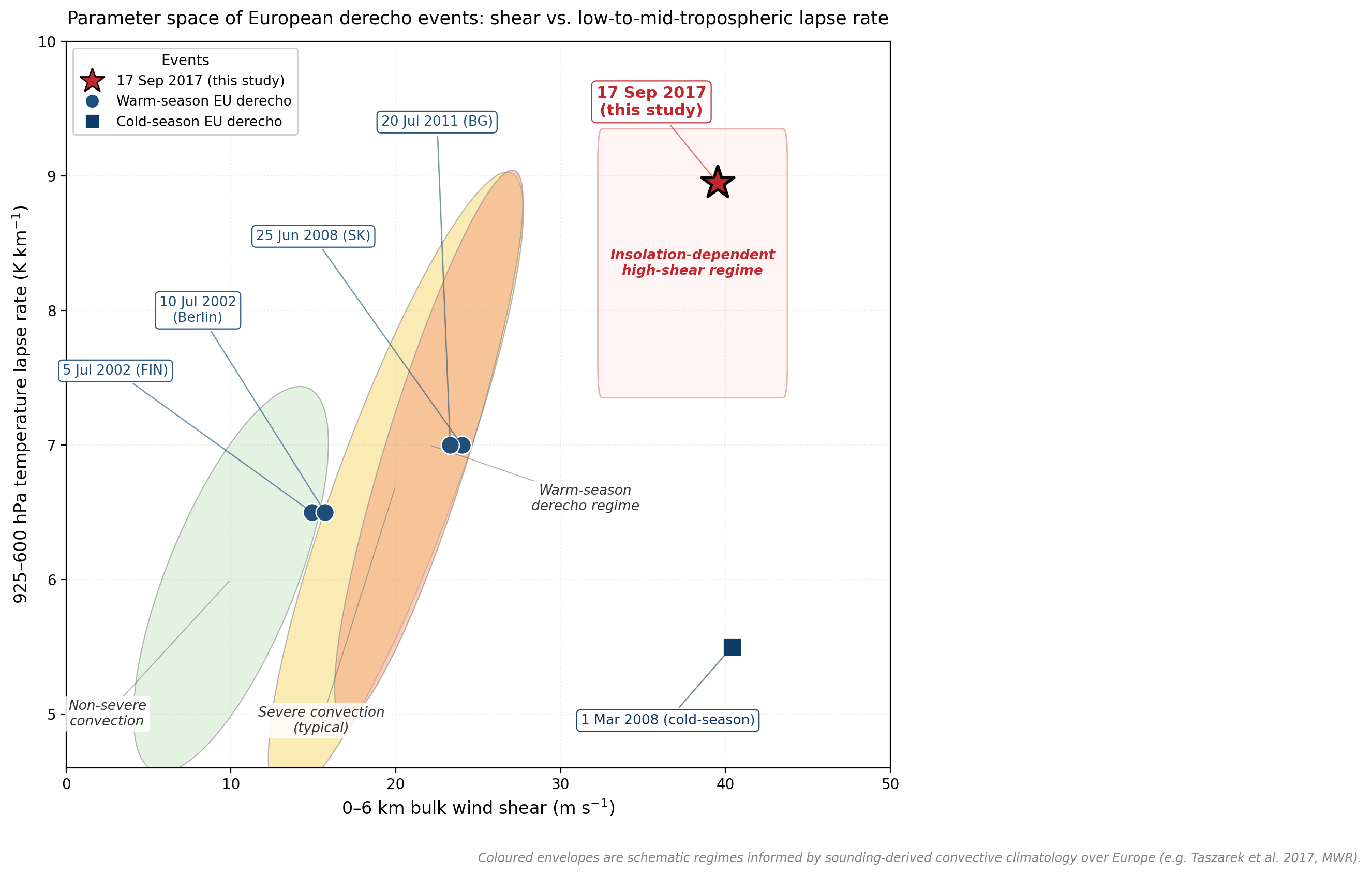
Finding 3: The event populates a sparsely-sampled corner of (shear × lapse rate) space
In two dimensions, the case sits alone in a region that is conditional on insolation-driven CAPE generation. The classical European warm-season derecho regime clusters at lapse rates of 6.5–7.0 K km⁻¹; this event was at 8.95 K km⁻¹.
Finding 4: HSLC-tailored indices detect the event; CAPE-anchored indices fail
The Derecho Composite Parameter (DCP), the SPC standard for derecho potential, returns 0.07 for this environment, against a severity threshold of 2.0. SHERBS3, designed by Sherburn & Parker (2014) for low-CAPE regimes, returns 1.55, above its threshold of 1.0.
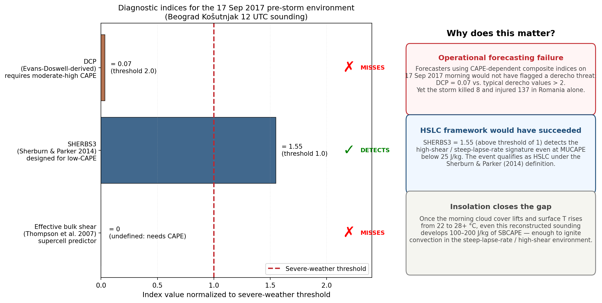
To my knowledge, this is the first demonstration that the U.S. HSLC framework correctly fires on a European derecho - an operational result with potential value for ANM and OMSZ forecasters.
Tentative conclusions (March 2026)
The picture that emerges is one of compounding drivers: no single ingredient explains the event’s severity in isolation, and standard CAPE-based forecasting tools miss it because they implicitly assume a different regime. The severity emerges from the simultaneous alignment of (a) anomalous warm advection at low levels, (b) very steep mid-tropospheric lapse rates, (c) extreme deep-layer shear, and (d) the few-hour window of afternoon clearing that pushed the surface parcel over its inhibition.
If this picture holds up under more rigorous testing, the operational implication for southeastern European forecasting is concrete: complement CAPE-based composite indices with HSLC-tailored ones, and explicitly track expected morning cloud break-up on days with otherwise unfavourable CAPE forecasts.
Future work and roadmap (March 2026)
Use the original radiosonde data. I want to replace the reconstructed Beograd Košutnjak sounding with the IGRA / University of Wyoming archive record and re-run the sensitivity analysis with measured (not estimated) 0–3 km shear. This eliminates the largest source of quantitative uncertainty.
ERA5-based search for analogue events. Scan the 1979–present reanalysis for transition-season days over southeastern Europe with the joint signature (T anomaly > 5 K, 0-6 km shear > 30 m s⁻¹, 925–600 hPa lapse rate > 7.5 K km⁻¹), and then cross-reference with ESWD damage reports. This enables a regional climatology of the proposed “warm-anomaly HSLC” sub-class.
SHERBS3 climatology over Europe. Compute the index across the European ERA5 domain and quantify its operational gain (POD vs. FAR) against DCP for the identified events. To my knowledge, this evaluation has not been done for Europe.
High-resolution numerical sensitivity experiments. ULtimately, I want to run a convection-permitting WRF or AROME simulation of the case, then artificially cap the morning insolation in a sensitivity run to test whether the storm fails to develop. This is the most direct test of the insolation-trigger hypothesis.
Operational deployment. Engage with ANM and OMSZ forecasters to evaluate whether HSLC-tailored indices and a morning-cloud-cover diagnostic would have practical value in their workflow.
Sources and acknowledgements
The foundational case study is Sipos, Z., A. Simon, K. Csirmaz, T. Lemler, R.-D. Manta, and Z. Kocsis, 2021: A case study of a derecho storm in dry, high-shear environment. Időjárás, 125, 1–37. The HSLC framework is from Sherburn, K. D., and M. D. Parker, 2014: Wea. Forecasting, 29, 854–877. Full reference list in the PDF.
All Python code, the reconstructed sounding, and the figure-generation scripts are available on request.